The Coast to Coast Path

The Coast to Coast Path (C2C) traverses northern England for a total distance of 192 miles. Most walkers travel from west to east, from St. Bees on the Irish Sea to Robin Hood's Bay on the North Sea. The path was proposed and designed by Alfred Wainwright in the 1970s. It crosses through three national parks, including the Lake District, the Yorkshire Dales, and the North York Moors. Most of the walk is on park hiking trails and public footpaths through private land; there are a few stretches on paved back roads. The C2C path was originally proposed as a twelve day walk, but more days can be added to allow a more leisurely pace.

Monday, June 20, 2011

Day 13: June 20, 2011 - Richmond to Danby Wiske

Today we walked 11 miles from Richmond to the village of Danby Wiske.  This part of the C2C path crosses a swath of agricultural land known as the "Vale of Mowbray"  (we called it the "Vale of Mordor").  It is flat walking with no opportunities for elevation gain - field after field, gate after gate.  The architect of the C2C path, Alfred Wainwright, described this area as being without much redeeming value (he liked to get up high!), but we found it attractive and interesting enough.  His original guide suggests covering the entire 23 miles of this section in one day, to get it over with.  We broke it into two parts to allow for some leisurely walking and picnic time.

The day began as we left Richmond and its castle tower behind, crossing over the River Swale.and heading east toward the North Sea.  We have miles to go, but we both felt the excitement of entering the final phase of our trek.


After following the banks of the River Swale for several miles to the garrison town of Catterick, the path eventually left the river for good and set off across open country.  The land was flat and fertile, mostly dedicated to agricultural use.  The walking was level and easy, but route finding was sometimes an issue.  In the photo below, the path crosses right through the middle of a potato field!


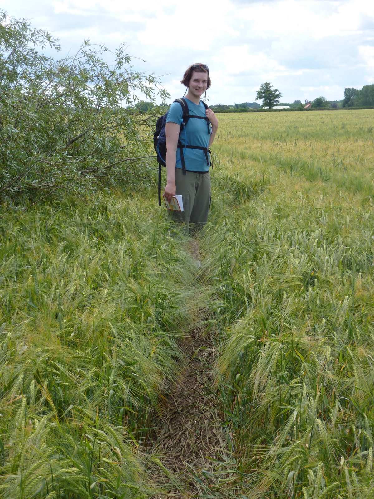
This is another typical scene from the day, as the path follows the margin of a field of barley.


After seemingly endless fields and gates, only four more miles to go!


We had some road walking today, mostly along farm roads like this:


 Here is a beautiful view of poppies and buttercups:


The barley in this field is ripening and almost ready to harvest.  The path winds through the field and is very difficult to follow at times.  There is a discernible pathway, but is it mostly covered by the barley and you can't see it unless you're standing on it!  It's easy to miss a turn and head out across a field in the wrong direction.  We did a bit of wandering around in this maze before picking up the path on the other side.

Here we enter Danby Wiske and the welcome shade of the White Swan Inn.  We spent the night at a B&B next door, and enjoyed a great pub meal  after chatting with some other British hikers.  The sign on the side of the pub says:  "Robin Hood's Bay - 60 miles."  We are more than two-thirds of the way now, and the realization that we're actually going to make it is beginning to sink in.


The end of another good day in the hills and ales:  Black Sheep Bitters

Sunday, June 19, 2011

Day 12: June 19, 2011 - Rest Day in Richmond

Richmond is the largest town on the C2c path. The town and its market square grew up around a castle, which was constructed after the Norman Conquest by a French nobleman who had been given the lands of Yorkshire for his loyal military service.  Parts of the castle still stand.  The streets in the oldest parts of the town are narrow spokes radiating out from the market square and its church.  Here is a photo of the castle grounds and some of the old walls:


And here is a photo of the old town from the top of the castle tower:


Richmond is also the home of the Georgian Theatre Royal, the most complete theatre from the Georgian period in England.  It was built in 1788, then closed in 1848 and was used as a storehouse for more than a century until being rediscovered and reopened in 1963.  We were fortunate to join a tour of the original building, along with its modern addition.  Here's a photo:


There are many lovely old buildings on the side streets, especially on Frenchgate, the street where our B&B was located.  Stepping into one of these from a busy modern road, there is the sense of entering a medieval village.  Here's another photo of the old and new:


The town today is receptive to tourists, including Coast to Coast walkers.  This pharmacy window was amusing, presenting a variety of products for the sore feet of C2C survivors:


The best part of Richmond from Laura's point of view was this French bistro where we had a delicious dinner at a bargain price.  Check out "Rustique" the next time you're in Richmond, and tell the restauranteur Marc that Laura sent you.


Saturday, June 18, 2011

Day 11: June 18, 2011 - Reeth to Richmond

Our walk through Swalevale yesterday was supposed to be easy, but ended up wearing both of us out.  Today's walk from Reeth to Richmond was the same length (11 miles), but seemed to go much more easily and quickly.  It was a walk across gently rolling hills and farms, with few major climbs or descents.

The day began with a pleasant walk through the woods past the ruin of Marrick Priory, an old convent built in the 1100s.  In the photo below you can see Laura ascending "the nuns' steps" - a stretch of 375 stone slabs set into this ancient walkway to harden the path.  We were told that, as the church graveyards filled up in the more populous towns to the east, coffins were carried along this path en route to burial in the spacious convent grounds.  There are stone shelves along the way - "coffin rests" - for the laboring pallbearers to take a break.  This was hundreds of years ago, and now there are only the smooth, worn steps and the quiet of the woods.

 Here is a typical scene from the day, showing the C2C path as it crosses a pasture and climbs the hill beyond before descending to Richmond.


A word about footpaths and public access.  Most of the C2C path crosses privately owned land on public footpaths.  The landowners are obligated to provide access to the footpaths, even though these may cut through the middle of a barnyard, pasture, or field of crops.  Usually the farmers tolerate the walkers as long as they don't trample the crops or scare the animals.  Some even make a cottage industry of selling tea and soft drinks along the path - like a lemonade stand in the wilderness.  Relations aren't always positive, however, and when the farmers are annoyed they have some unofficial recourse - such as putting a bull to pasture in a field where the C2C path runs. Below we see Laura having an encounter with a very large bull who planted himself dead center on the path.  He wasn't moving, and Laura was the first to blink.  We gave him a wide berth, having heard stories of some walkers being chased to the fences after getting too close.


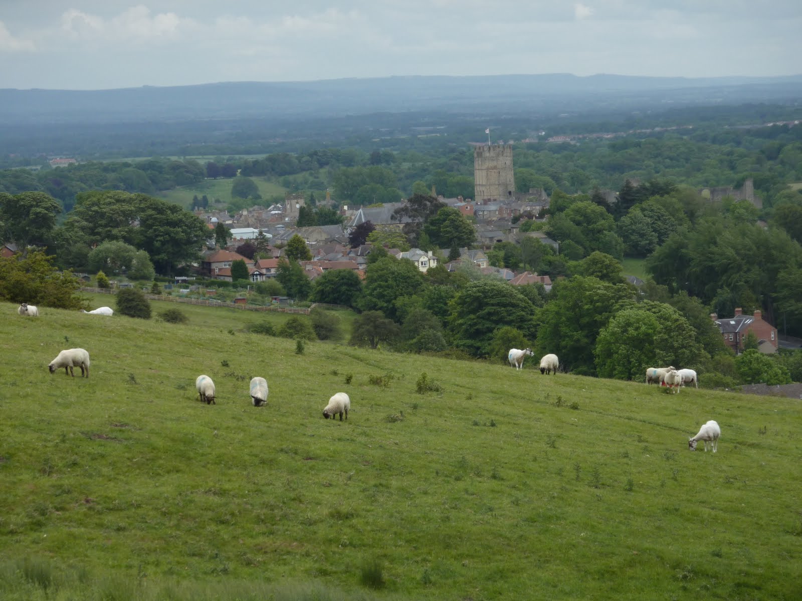
In due time we climbed over the ridge, through another lovely stretch of woods, and approached the town of Richmond on a farm road.  I keep experiencing the wonder of walking into a new village or town, compared with entering by car or train.  We had such a different sense of place, an awareness of the lay of the land, when walking.  Here's a view of Richmond from the favorite overlook of Alfred Wainwright, the genius who designed the C2C path in the 1970s.  You can see the tower of Richmond Castle in the market square in the center of town.


Here's the mandatory cute sheep shot:


And here is C2C guidance through the streets of Richmond.  We will stay here tomorrow for our second rest day, and hope to tour the castle and the theatre, which is one of the oldest in England.

Friday, June 17, 2011

Day 10: June 17, 2011 - Keld to Reeth

Today's walk of 11 miles took us from the remote village of Keld along the Swale River valley to the market town of Reeth.   Keld is tucked up in the western Dales on the headwaters of the Swale.  It is a tiny, self-contained stone village in a countryside populated mostly with sheep.  Here is a photo of the village in the early morning:


The Yorkshire Dales were settled 1000 years ago by Vikings.  Many of the place names are Viking in origin.  There were lead mines here from the time of the Roman occupation, and there are still ruins of lead mining operations from the previous century along the barren hilltops throughout this region.  The C2C trail as originally mapped takes the high route through these old mines.  There is an alternative route along the Swale River valley which is less exposed to the weather, and we opted for this cushier path today.  Here is a photo of "Swaledale":


Laura and I took a detour off the path to the village of Muker to check out a store selling woolen goods made by local artisans.  We enjoyed a cup of tea and a chat with some well-traveled Dutch hikers, but, alas, the woolen goods were too dear (and too heavy) for us to take away.  The path to Muker crossed a series of fields filled with wildflowers, on a walkway paved with flagstones.  Gate after gate, field after field, we walked through this golden paradise:


Here is a very contented resident of the region:


I loved the visual textures of the stone walls, and their patterns across the hillsides.  You may notice the walls as a central element in many of the photographs.  It is hard to capture the complexity of the countryside in a photo frame.  Here's another effort:


 Throughout our walk so far we have shared the countryside with a variety of animals, mostly sheep, but also cows and horses.  They are contained and separated by the walls, and every wall has gates for people and vehicles.  These may be stiles which require climbing over a fence or wall, or swinging "kissing gates" which open only enough to admit one person into an enclosure, and must be closed again for the person to exit on the other side.  Some gates appear designed to only admit the slimmest farmers and hikers, such as the one below:


Here's a view of the Swale River and the pastoral countryside which it flows through on its way to the North Sea some 80 miles downstream:


Here's an abandoned stone barn in the corner of four fields.  In the days before motorized tractors, hay could not be transported far for storage, so barns were constructed for the fields abutting them.  Most are abandoned now, but are maintained and preserved as historic buildings.


The end of our day came after a walk through the town of Reeth to "The Barn", a lovely B&B on the opposite side of town.  We enjoyed a pub meal and a pint at the Bridge Inn, and gratefully put our heads down on some really nice pillows.

Thursday, June 16, 2011

Day 9: June 16, 2011 - Kirkby Stephen to Keld


Today's hike took us out of the market town of Kirkby Stephen, over the Pennines, and into the Yorkshire Dales to the village of Keld.  It was a notable day for several reasons:  in crossing the Pennine Range we  moved from the western to the eastern watershed of England, and reaching Keld marked the halfway point of our walk - about 100 miles from our starting point at St. Bees.  The day began with ominous dark clouds and drizzle.  We had hoped to take the high route past the "Nine Standards", a cluster of rock cairns on the ridge over Kirkby Stephen.  However, as we climbed up the clouds moved in, and the rain came down.  Here is a distant view of the Standards as we approached in the rain


So, we had to make a choice:  the lower "green route" which follows the road around the ridge (boring, but hard to get lost on), or the "red route" up to the standards and over the moors.  The advice is not to proceed if you can't see the Nine Standards because of low clouds or rain.  We couldn't see them, so we were preparing to go the low way.  As we stood in the rain and talked with other hikers, the sky started clearing, until suddenly the way was clear!  It felt like a divine reward for our patience (or indecision).  Anyway, we took the high route and here is the view of the Standards from the top:


Laura and I thought the this standard would look better with some color-coordinated decorations:


The trip down from the ridge across the moors was tricky.  Navigation was by following the cairns, which were difficult to see even in clearing weather.  In addition, this part of the trip is notorious for the breadth and depth of its peat bogs.  Hikers have gone in up to their waists when thinking that they were stepping into a mud puddle.  Here's a photo of a stretch of peat bog with some wisps of fog:


And here is Laura slogging through the bog.  She only went up to her ankes, but I went in up to my knees at one point.  I was really hoping that my boots were going to come out of the mud along with my feet!

 It all came to an end eventually, and we set off on a hard tarmac road (welcome for once) for the rolling hills of the Yorkshire Dales district.  This area is very rustic and beautiful.  It is the site of the James Herriot novels.  Here's a typical scent of the Dales with one of the old-fashioned stone barns which dot the landscape.

.
We were very happy to roll into the Keld Lodge late in the afternoon and shed our muddy clothes.  The next day will take us down the Swale river valley to Reeth.

Wednesday, June 15, 2011

Hiking across the sheep pastures ...

Day Eight: Wednesday, June 15 - Orton to Kirkby Stephen

 Our day began in Orton, small village slighting off the C2C trail. Orton may only have one pub, but it does have a Chocolate Factory, which - as you might imagine - was our first stop into town the previous afternoon.  After several hours of hiking, the dazzling variety of a serious chocolaterie was a bit overwhelming.  That evening we explored the town a bit, discovering a house built in the 1600s (still very much standing, and quite sturdily at that), a bird sanctuary, and this charming and hilarious building:


Leaving the charm of Orton, we set off for Kirkby Stephen, one of the largest towns on our walk.  It rained, as it has most every day, but the scenery was still lovely as ever.  We spent our first big chunk walking on the road, partially because we missed our turn and partially because it's rather less difficult in the rain.  Once we made it back onto the trail, the day looked much like this:


There were plenty of rolling hills, barns, rock walls, and of course, sheep.  We even came across a particularly amusing herd of cows, carefully labeled by their obviously detail-oriented owner:


We also got a bit off track later in the day, passing through this railway tunnel:


 Instead of this one:


Perhaps you understand our confusion...

But we got to Kirkby Stephen just fine, after ambling past a very important but unexcavated archeological site (a contradiction in terms, it seems to me).  Walking into these old villages is an entirely different experience than driving in, as Dad keeps commenting.  You can sortof feel them coming as you glimpse a few clustered chimneytops, but it's not until you reach an alley like this one that you really know you've arrived:


Though it may not seem like much from the snapshot below, Kirkby Stephen was a jarring and cacophanous metropolis compared to the villages we'd been staying in to date.


But the big city (and by big city of course I mean moderately-sized village) can have some benefits; we found ourselves an Indian restaurant and had a spectacular dinner.  But the real excitement came at the end of a little alleyway between the church-turned-market and the Fish'n'Chips shop:


 Yes, clean clothes for all.  I'm sure our upcoming innkeepers will be grateful.

Tomorrow it's over the Pennines to Keld, the halfway point of the walk.  More stories and pictures to come soon!